Articles by Tracey

I like data and think it should be shared at not cost! Especially public data!

Updated April 29, 2013

If you are planning an Open Data event, an expert panel on the topic, looking for a conference speaker, or someone to interview for a news article, you might want to consider inviting some of the experts from this list.

If you know of people to add, please email me – tlauriau at gmail dot com.

Canada:

  • Mary Beth Baker, Founding member of Open Data Ottawa, website
  • Natalie Black, programmer for Nimonik.ca
  • Ashley Casovan, Strategic Coordinator – Advisor to the CIO at  City of Edmonton, ashley dot casovan at edmonton dot ca
  • Julia Evans, data scientist & programmer. About.
  • Trish Garner, City of Toronto, Manager of Web Strategy, @trishgarner, Open Data Portal
  • Tracey P. Lauriault, Founding member of CivicAccess.ca list, Datalibre.ca, blog & bio
  • Heather Leson, Director of Community Engagement at Ushahidi, and see Textontechs, bio
  • Hillary Little, UI and Design, bio
  • Alison Loat, Samara, bio
  • Ellie Marshall, Open Northellie at opennorth do  ca
  • Diane Mercier, Open Data Advisor Ville de Montréal, Website
  • Josee Plamondon, app developer Contratsnet, jplamondon at gmail doc com
  • Gina Porcarelli, City of Toronto, Linkedin
  • Catherine Roy, Citizen member of the City of Montreal Table de concertation, web consultant, BIO
  • Laine Ruus, first data librarian in Canada, University of Toronto, Bio
  • Sheyda Saneinejad, Engineer, Innovation Lab
  • Teresa Scassa, Canada Research Chair in Information Law, Blog, Bio
  • Karen Smith, I School U of T, Bio
  • Wendy Watkins, Founding member of the Data Liberation Initiative (paper), contact

International:


I just came back from a whirlwind trip to Taiwan and Japan.

In Taiwan I presented a the CODATA 2012 conference Open Data and Information for a Changing Planet.  CODATA (Committee on Data for Science and Technology) is an interdisciplinary Scientific Committee of the International Council for Science (ICSU), which works to improve the quality, reliability, management and accessibility of data of importance to all fields of science and technology.  Canada has a Canadian National Committee for CODATA, based out of The National Research Council of Canada Institute for Scientific and Technical Information (CISTI) and the focus is scientific and research data and their preservation.  CODATA are the systems of systems folks, focusing on large data infrastructures.  The World Data Systems (WDS) folks also joined the conference and I had the good fortune of meeting some World Data Centre (WDS) directors. WDCs are a critical component in the sharing and preservation of scientific data and they undergo a rigorous certification process which many open data cities, provinces and federal initiatives might want to consider in their planning.

There were many great sessions at the conference, and the Mass Collaboration Data Project and Policies session is particularly relevant here.

  • Shun-ling Chen, a Harvard Law School PhD Candidate, provided a historical review of copyright and how mass collaboration projects are changing perspectives.
  • Puneet Kishor from the Creative Science Commons, a renowned CC0 advocate announced that he was willing to accept that scientists and scientific data need attribution, something I thought was quite obvious, but it seemed to be revelatory to him.  He also showcased his earth-base project which provides another way to search for scientific data.
  • Mikel Maron from GroundTruth Initiative discussed Open Street Map (OSM) in developing countries, particularly those who suffered a disaster.  He re-iterated that OSM is a community project not a crowd project, as crowd has negative connotations and he also discussed the issues related to place name politics whereby it was important to sometimes shut down the ability to change the names of contested places.  This brought tension to a consensus process like OSM.
  • Kerstin Lehnert, of Integrated Earth Data Applications (IEDA) discussed the integration of physical things and the need for uniform metadata for samples in order to do so.  We have the Internet of Things but the physical things that are sampled are not very well connected to the Internet.
  • Te-En Lin introduced a Citizen Science roadkill project in Taiwan.  It used FB as a means to get citizens engaged in photographing the road kill they encountered.  The project continuously had to refine its process as scale was an issue when identifying squashed critters, and so they taught people to put their shoe or other identifiable objects beside the creatures.  Eventually, people were going to corner stores and laminating their finds and sending them to him.  Hilarious.  He now has approximately 800 jarred samples which are all georeferenced and they will be using these data to develop remediation projects.
  • Mike Linksvayer, was provocative in stating that copyright makes us stupider and is stupid and that it should be abolished all together.  I argued that for traditional knowledge where people are seriously marginalized and where TK is exploited, copyright might be the only way to protect themselves.  We wound up having a late night jet lagged discussion in the hall way of the hotel and I think we understood each others perspectives more while still maintaining our stances.  He also introduced his submission Future of Copyright to the Future of Copyright contest for which is was classed in the top 10.

In addition to the conference I organized a meetup of local open data folks in Taiwan.  Open Data Taiwan graciously accepted the invitation and organized a dinner at a great Thai Restaurant and at a local cafe.

  • Weitze CHANG (aka Whisky), from the Youth Synergy Taiwan Foundation, a social enterprise promoting critical thinking, answered the call and organized a local meetup.  He facilitated some great discussion on open data challenges in Taiwan and was very interested in the kind of work being done in Canada, the UK and Internationally.
  • Dennis Raylin Chen also from the Youth Synergy Taiwan Foundation, did much on the ground coordination and participated as a citizen journalist at the CODATA 2012 conference.
  • Jack Townsend, who presented a project at the conference called globe-town.org also joined and shared some of his knowledge about the open data work he does on sustainable development.
  • 4-5 other fine open data folks also joined the meetup and I will post their contact when I have them.

We were also shown two very interesting open data projects.

Space is at a premium in Taiwan and there was much price gouging as no one really knew what things actually cost relative to each other as these data were never published.  The government tried to release them on a case by case basis until their system crashed as robots were endeavouring to scrape the data minutes after it was launched at midnight on a weeknight.  The government relented and released the entire dataset and this mashup is the result of that.

This visualization provides many views to how the Government of Taiwan spends.

I will update this post as my new friends in Taiwan send me more information.

The University of New Brunswick invited me to give the Keynote at their inaugural Open Access Week Annual Conference: Bailiwick.  The Conference was organized by the Information Services and Systems at UNBSJ who are developing an Open Access Plan, developing an institutional repository to preserve and manage their research output. I had the good fortune of spending an afternoon with the Library and Information System staff, tour the campus and visit the town. The objective of the talk was to introduce what open means and not only on open data.

Presentation links in order of appearance:

Scenarios:

Where to find data:

Data Access Advocacy:


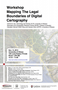
Mapping The Legal Boundaries of Digital Cartography Workshop
Centre for Law, Technology and Society (CLTS)
the Geomatics and Cartographic Research Centre (GCRC) and the Canadian Internet Public Policy and Interest Clinic (CIPPIC)
Nov. 14, 2012
Louis Pasteur Hall, Ottawa University
Room: LPR 285
13:15 – 17:00

Theme:
Surveying the legal terrain and charting the course
Moderated by:
Tracey P. Lauriault
Welcome:
13:30 – 13:40: Introduction – D. R. Fraser Taylor, GCRC & Teresa Scassa, CLTS
Traditional Knowledge:
13:40 – 13:55: Traditional Knowledge and Legal Digital Cartography, Teresa Scassa, CLTS
13:55 – 14:10: Toward a Traditional Knowledge License, David Fewer, CIPPIC
14:10 – 14:25: Embedding Law in an Indigenous Atlas Infrastructure, Amos Hayes, GCRC
14:25 – 14:45: Inuit Knowledge Stewardship, Scot Nickels, Inuit Tapiriit Kanatami (ITK) and Timothy Di Leo Browne, Canadian Studies  Student, Carleton University
14:45 – 15:10:  Discussion
Authorship and Digital Cartography:
15:10 – 15:25: Third Party Use of Base Maps, Adam Saunders, Law Student, Ottawa University
15:25 – 15:40: Copyright and Joint Authorship in Cartography, Elizabeth Judge, CLTS
Practical Geospatial Policies – Resolving Operational Issues
15:40 – 16:00: Simon Riopel and Sophie Sliwa, GeoConnections, Natural Resources Canada
Discussion
16:00 – 17:00

A group of open data specialist participated in the Civicus World Assembly in Montreal as panelist for a session called: How civil society can (and already does) use open data.

The session was well attended and generated some excellent questions from people from IT in Yemen, Nepal, IDRC, non-profit IT, health practitioners, UK third sector academics, a city ombudsperson, philanthropy, citizen scientists and more.  It was promised that we would share the resources mentioned at the session and here they are:

MORE Forthcoming.

Une initiative citoyenne à but non-lucratif et non-partisane qui a pour but de promouvoir l’accès ouvert aux données civiques de la région de Montréal.
Une initiative citoyenne pan-québécoise à but non-lucratif et non-partisane qui a pour but de promouvoir l’accès ouvert aux données civiques de la province du Québec.
Portail des données ouvertes de la Ville de Montréal
Portail des données ouvertes de la province du Québec.
Application web qui situe et visualise l’état des patinoires en utilisant les rapports quotidiens de conditions des patinoires de la Ville de Montréal.
Application web qui géolocalise et analyse par type d’établissement les rapports d’inspections de salubrité des restaurants montréalais.

Guest Blog post by Mark Weiler:

Thirty-years ago, on July 7th, 1982, the Parliament of Canada gave Royal Assent to the Access to Information Act, which became Canada’s first freedom of information legislation.

The Access to Information Act is important for Canadian society because it is through this legislation that the Parliament of Canada, the highest authority in the country, grants Canadians permission to access information held by approximately 250 departments of the federal governments, overruling lower authorities within government who might think otherwise.

With Royal Assent, a transformation began that turned most departments in the federal government into something like public libraries, or perhaps public archives. The transformation would reach a milestone on July 1st 1983 when the Access to Information Act became enforced.

However, in the thirty years since Royal Assent something of a betrayal has occurred. When given a public platform, FOI users, such as the media, often perpetuate narratives premised on the message that “the Access to Information Act is broken.” While this might get public attention and bolster a worthy goal of holding government more accountable for failures to properly implement the Access to Information Act, perpetuating this message also betrays the broader Canadian public.

Such a message is a betrayal because it gives the impression that there’s no point in using the Access to Information Act; it is a discouraging message. But to say the “Access to Information Act is broken” is a bit like pronouncing the public library “broken” because some people are having a problem accessing materials on the 7th floor while these and other FOI patrons are successfully accessing materials on every other floor in the library.

Yes, those materials on the 7th floor are important; and yes it’s a serious problem if politicians or government officials are unlawfully withholding them. But it’s misleading to give people the impression that the “public library” is shut down.

The reality is the Access to Information Act works for many people. In 2010-2011, materials were “checked out” almost 42,000 times from approximately 250 federal departments. If the Access to Information Act was broken, then this statistic should be part of a downward trend. But in the last ten years, the number of “check outs” has increased year by year.

We therefore have reason to believe that the Access to Information Act, grounded in Parliament’s decree that every Canadian “has a right to and shall, on request, be given access to any record under the control of a government institution”, is working even though it could do better in some circumstances.

To regain faith in how government department’s live up to Parliament’s decree, it is worthwhile to look at what people and organizations have been “checking out” of this new brand of public information repositories. The federal government has adopted a policy of posting “summaries of completed ATI requests” on almost 140 departmental websites, so it’s easy to get a sense of how people are benefiting from the permission granted to them by Parliament thirty years ago. Links to these departmental webpages can be found here.

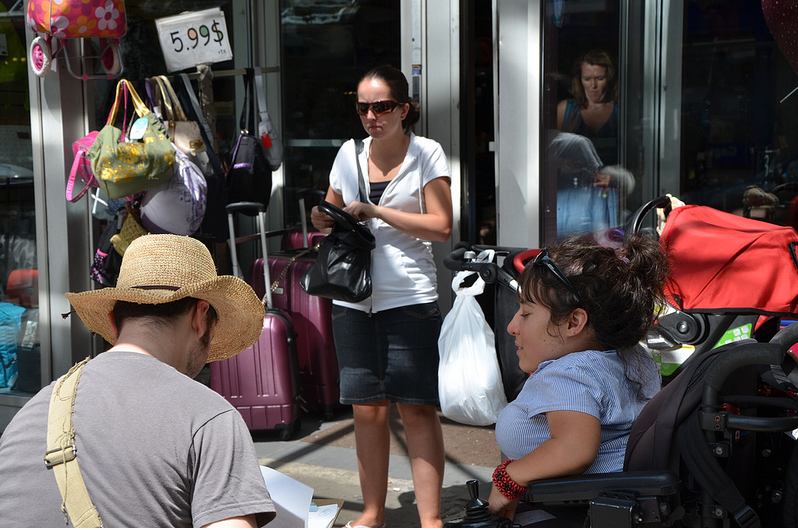
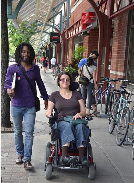
Over the weekend I had the privilege of participating in the Journée de l’accessibilité de Montréal accessible co-organized by Catherine Roy of RAPLIQ (Group for an inclusive Québec) and Jean-Noé Landry of Montréal Ouvert.

This was an extremely well organized event.  A week before shop keepers were advised by way of posters and handouts that a survey in their neighbourhood was going to be conducted.  People pre-registered which allowed for the creation of teams.  At noon on June 30th we gathered in an accessible square where we received instructions, picked up water supplies and met our team members.  There were 9 teams of 3 or 4 members each, equipped with a list of addresses and the name of establishments on Saint-Hubert street in Montreal.  It is a lovely street in the north of Montreal close to the Jean-Talon market.  Most importantly, the sidewalks are covered which makes this an ideal shopping space in the winter for people in wheelchairs.  We all had a clip board, blank survey sheets, annex survey sheets to assess restaurant washrooms, and a pen.  All teams comprised a person with disabilities, either visually or mobility impaired.  My team included Pierre Lemay, Xavier, and a city Councillor.

The process was to go to shops, boutiques, hair & nail salons and restaurants to evaluate the accessibility of: entrances, doors, the interior passage ways between wares, change rooms, washrooms, interact machines, the size of price tags and the conviviality of shop keepers.  We were well received by the shop keepers and it became an educational moment for able bodied data collectors who most often had to leave a member of their team at the door as they could not enter and for shop keepers who realized that a doorbell could make a world of difference to people in wheelchairs who would otherwise not be able to make a purchase.  Getting an ice cream cone on a hot day was a challenge.

At the end of the day, the organizers arranged for all to meet at an outdoor patio to drink a free beer provided by the Montréal Ouvert crew. This was a time to verify gathered data, recommend survey adjustments, and exchange experiences.  The collected data will later be entered into a database and then mapped.

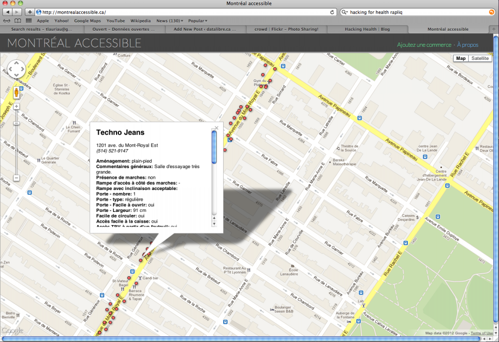
The first prototype of this project was created on Feb. 25, 2012 as part of a Hacking for Health event and this is their first map.

That team won the Hacking for Health contest and were awarded 400$, and some of those proceeds were used to purchase the 1st beer on Saturday.  I look forward to seeing the maps, hearing about how the results will be analyzed and then disseminated.  It was a great way for me to spend a Canada Day weekend with friends in Montreal and doing some citizenship.

Finally, this was a great way to match up disability activists and advocates, citizens at large, open data app developers, folks from Open Street Map, and public officials.  It was a day to hack space in an inclusive and low tek way.  The digital tek will come afterwards.  We also got a glimpse of the material effects of spaces produced from an able bodied geographical imagination.  I got closer to understanding what an inaccessible city is, and how we spatially segregate citizens with the built environment and this participatory mapping and data collection event was a great way for a group of people to collectively re-imagine the city and by doing so changing space.

Coders for Libraries, code{4}lib looks really interesting! 

Date:

  • Wednesday June 13th, 5pm

Location:

  • The Exchange Pub, 50 Rideau Street (entrance inside the Rideau Centre).  The reservation is under “Warren / code4lib” and the reserved room is downstairs.

Agenda:

  1. recap of the code4lib North unconference in Windsor
  2. lightning talks (about 5 minutes each).
  3. social gathering

Volunteers:

  • Developers from the Ottawa Public Library will give a preview of the API to their BiblioCommons catalogue. The API will be
    publicly available this fall.
  • William Wueppelmann will talk about Canadiana.org and how they host and manage their huge digital collection and efforts to achieve certification as a Trusted Digital Repository (TDR) (i.e. a digital archive).
  • Mary Beth Baker will talk about the local tech scene in Ottawa and the potential for collaboration.

Anyone who wants to demo what they’re working on or talk about something  related to libraries and technology is encouraged to take the floor. An HDTV with an HDMI input is available

Please see the code4lib North wiki page for the most up-to-date information about this meetup.

If possible, please send an RSVP to warren.layton@gmail.com if you wish to attend and/or present a lightning talk.

See you at the meetup!

I just successfully defended my PhD dissertation in the Department of Geography and Environmental Studies at Carleton University.  It provided me with tremendous insight into the historical evolution of data classification systems, how these influence society, construct spaces and in turn are shaped by and shape our geographical imaginations.  By examining classifications it is almost inevitable that one must also look into data infrastructures which normalize so many of our practices (e.g., GoogleMaps, geospatial data infrastructures).

I look forward to being away from this material for a little while, but I will most definitely come back to it, as I think it has some important implications for open data.  Currently Canada’s geographical imaginations, from a data perspective, are primarily governmental, however, with the advent of open data, shared infrastructures, interoperability, open specifications, open source and demands for greater government transparency, I believe, we will see the co-construction of a new imagined/modeled Canada.

In the grand scheme of things, Open data and open government are pretty new movements, but if the momentum continues, and if we become better deliberators and increasingly numerate, I think we will begin to see a real citizen/government evidence based decision making culture.  And I really look forward to that.

Until then, below is my abstract and the defence presentation if you care to read/look at it.  I am not entirely sure what is next, but I do have the good fortune  of being a post doctoral fellow at the Geomatics and Cartographic Research Centre (GCRC) working on the SSHRC Partnership Project entitled : Mapping the Legal and Policy Boundaries of Digital Cartography with Centre for Law Technology and Society, Natural Resources Canada and the great folks at the Canadian Internet Public Policy Internet Clinic (CIPPIC).  I will also be doing some work on the preservation of scientific data, even if we do have have a functional national archive.

ABSTRACT:

The central argument of this dissertation is that Canadian reality is conditioned by government data and their related infrastructures.  Specifically, that Canadian geographical imaginations are strongly influenced by the Atlas of Canada and the Census of Canada.  Both are long standing government institutions that inform government decision-making, and are normally considered to be objective and politically neutral.  It is argued that they may also not be entirely politically neutral even though they may not be influenced by partisan politics, because social, technical and scientific institutions nuance objectivity.  These institutions or infrastructures recede into the background of government operations, and although invisible, they shape how Canadian geography and society are imagined.  Such geographical imaginations, it is argued, are important because they have real material and social effects.  In particular, this dissertation empirically examines how the Atlas of Canada and the Census of Canada, as knowledge formation objects and as government representations, affect social and material reality and also normalize subjects.  It is also demonstrated that the Ian Hacking dynamic Looping Effect framework of ‘Making Up People’ is not only useful to the human sciences, but is also an effective methodology that geographers can adapt and apply to the study of ‘Making Up Spaces’ and geographical imaginations.  His framework was adapted to the study of the six editions of the Atlas of Canada and the Census of Canada between 1871 and 2011.  Furthermore, it is shown that the framework also helps structure the critical examination of discourse, in this case, Foucauldian gouvernementalité and the biopower of socio-techno-political systems such as a national atlas and census, which are inextricably embedded in a social, technical and scientific milieu.  As objects they both reflect the dominant value system of their society and through daily actions, support the dominance of this value system.  While it is people who produce these objects, the infrastructures that operate in the background have technological momentum that also influence actions.  Based on the work of Bruno Latour, the Atlas and the Canadian census are proven to be inscriptions that are immutable and mobile, and as such, become actors in other settings.  Therefore, the Atlas of Canada and the Census of Canada shape and are shaped by geographical imaginations.

The Creative Law Society and CIPPIC hosted a Creative Commons Salon on the topic of Open Data.  I was invited to represent the Geomatics and Cartographic Research Centre and speak about research data.

Abstract:

Most university based research is publicly funded and researchers use government data in their work, the data derived from the research of others, and also produce data as part of the research process.  The Geomatics and Cartographic Research Centre (GCRC) at Carleton University does this and also adheres to the principle that publicly funded research results should be created in such a way that they can be re-disseminated back to the public.  I will therefore discuss how the GCRC collaboratively collects, uses, maps and re-disseminates its data and will highlight some of the open data issues it encounters while doing so.  Also, it will be argued that even though the GCRC adheres to access principles, a lack of a national digital data archive and data preservation and management support from granting councils impedes the GCRC and others from sharing their data more broadly while open data strategies have yet to take research data into consideration.  Most notably, Canada does not have a research data archive, preservation policy nor a network of university based data repositories.

I gave a similar talk on March 21s, 2012 the same week at Ottawa University, however the focus in that case was librarians in becoming and faculty at the School of Information Studies.  That presentation is here.


« Older entries § Newer entries »